


Google says its release of location data will assist local health authorities better understand how effective social distancing measures are in a given community.
Google has publicly released a series of COVID-19 Community Mobility Maps, utilising location history data from users around the world to present insights into how people are moving around local communities.
The data is presented to highlight how social distancing and shelter in place measures are changing people’s behaviours.
In countries that are several weeks into strict stay-at-home lockdowns the reports certainly indicate significant behaviour changes. Italy, for example, shows a 94% drop in retail and recreation behaviours, and an 87% drop in visits to transit stations. Sweden, on the other hand, a country that controversially has yet to declare a strong lockdown, shows only a 24% drop in retail and recreation behaviours, and a striking 43% rise in park visitations.
Google says this information will only be publicly available for a limited time, as long as public health officials find the data valuable. The reports will be updated consistently and adapted based on feedback from local governments and communities.
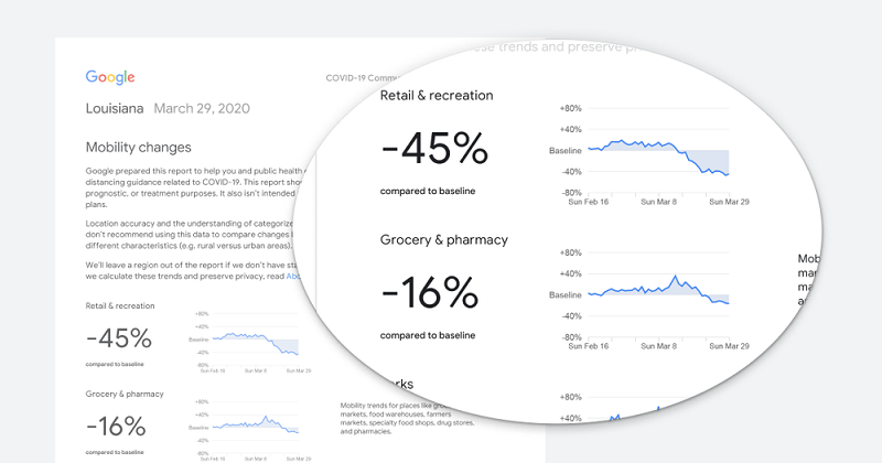
The initial release of these reports covers 131 countries, each offering a downloadable PDF comparing recent location data with similar data from over two months ago. Each report looks at mobility trends across six categories: Retail & Recreation (cafes, museums, etc), Grocery & Pharmacy, Parks (including public parks and national parks), Transit Stations, Workplaces, and Residential.
Each country report is also broken down by individual states or provinces. The United States reports are a little more granular, with individual PDF reports for each specific state allowing for more detailed county by county breakdowns.
The freely available reports span 131 countries, with individual state-by-state reports for the United States.
In a blog post explaining the public data release, Senior Vice President of Maps Jen Fitzpatrick and Chief Health Officer of Google Health Karen DeSalvo suggest the information is designed to help public health officials better understand the efficacy of local measures.
“For example, this information could help officials understand changes in essential trips that can shape recommendations on business hours or inform delivery service offerings,” the blog post explains. “Similarly, persistent visits to transportation hubs might indicate the need to add additional buses or trains in order to allow people who need to travel room to spread out for social distancing. Ultimately, understanding not only whether people are travelling, but also trends in destinations, can help officials design guidance to protect public health and essential needs of communities.”
Google is keen to stress this aggregated data is anonymised to make sure no user data can identify a specific person’s movements. Google also notes this data is only collected from users who have turned on their Location History setting, an opt-in setting that is switched off by default.
“While we display a percentage point increase or decrease in visits, we do not share the absolute number of visits,” the blog post says. “To protect people’s privacy, no personally identifiable information, like an individual’s location, contacts or movement, is made available at any point.”